
Data collected from satellites are becoming more and more common when monitoring biodiversity. How can satellite pictures be best used? And what can we learn from them?
The first satellite, Sputnik 1, was launched by the Soviet Union in 1957. The beach ball–sized craft, made of aluminum, sent out radio signals during its’ 92 days in space. It would take another 10 to 15 years of space-based Cold War armament for satellites to begin visually observing our planet. For a long time, however, the images were quite limited.
When Sputnik 1 set off on its maiden voyage, the concept of "biodiversity" had not yet been coined, let alone accepted. It did not gain traction in a research context until the mid-1980s, and it has only recently had a broader impact on the general public.
Today, satellites and biodiversity are increasingly linked. Images of the Earth's surface taken from space, and the data one can extract from them, have become more or less inseparable from biodiversity.
Heather Reese is a senior lecturer in remote sensing and GIS at the University of Gothenburg. She uses satellite data in her research, with a focus on biodiversity. Since she first began researching the field in the '90s, image quality and frequency have improved.
”For example, with the European Space Agency's Sentinel-2 satellite, you get a picture every five days at the equator and much more frequently near the poles. This is a very positive development.”

Register for our monthly newsletter THE EDIT
THE EDIT is Vattenfall's new monthly newsletter. Each issue highlights a new burning issue from the world of sustainable energy and fossil freedom.
An essential tool among others
Reese sees satellite images as one tool among many for collecting the data needed to study biodiversity. Satellite images provide an overview and can capture larger areas of landscapes and detect extensive changes.
”When it comes to biodiversity, for example, one can obtain a lot of data on vegetation variations. Is it growing significantly? Does it become greener? Does it become more productive? In arctic and alpine areas, which I study, one can observe "shrubification," meaning that bushes grow more as the climate warms up. We can also look at the opposite effect, called ’browning’, where plants become less productive or even die due to drought or frost damage. One potential cause is that snow melts earlier and protection as well as water availability decreases.”
Satellite images also provide the ability to see development over time. Satellites can collect reliable global data over a long period of time, making it possible to follow the major events in an area.
”With satellite images, one can go back as far as the 1970s and 1980s to see how vegetation has developed.”
Automatic helpful updates
In her own research, Reese uses satellite images in combination with field studies and drone surveillance. She sees them as a tool among many others.
”How one uses satellite images depends greatly on what one wants to observe. Some of my research uses only satellite images and fieldwork because I believe you always have to go out into the field, but I've also had projects where I only use drones. In those cases, someone has to go out and actually fly the drone, whereas satellites provide updated images automatically.”
Heather Reese exemplifies the difference between satellite and drone monitoring with a project the University of Gothenburg is currently undertaking with the University of Lund, looking at pollinators. Drones with multispectral cameras and LiDAR are used to map pollinator habitats, such as the height of vegetation and how much potential shade it provides. Satellites are more often used for larger area analysis and analyze biodiversity in terms of the landscape characteristics.
”In the pollinator project, we fly drones to take very detailed images at a few timepoints during the summer. Meanwhile the satellites just keep operating all the time and collect data with high frequency. This way we can follow, for example, the phenology of the vegetation during the time we don't use the drones. We get the time and landscape perspective with satellites and can combine that with drone data to get the level of detail we need for the pollinators.
Energy and resources used at the right place
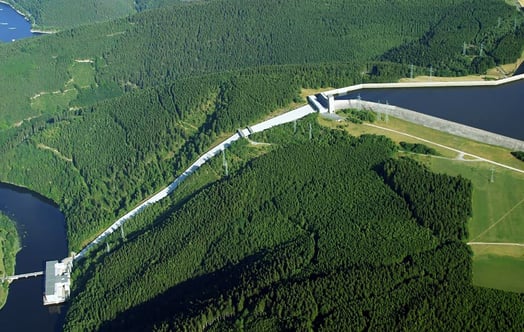
Dag Wästlund, manager of Vattenfall's Data Science and AI section, has used satellite images and data from them in a similar way - to get an overview, not least when it comes to thinking about biodiversity in combination with hydropower.
"In the past, the measures we have planned have been very site-specific. We have had to go out and make an inventory on site, but we have not had the overview. With satellite imagery, we can identify the right places from a restoration point of view or to create, for example, riparian wildlife much easier. We can look at the whole picture and choose the places that are most affected, so we spend energy and resources on the areas where we can make the most difference.”
Satellite imagery has also been useful for monitoring biodiversity in connection to electricity distribution.
”Satellite imagery has made it much easier to identify the different types of habitats found in, for example, overhead power line corridors. This could give us a summary of power line corridors all over Sweden and how they have developed over the years. In this way, we have the possibility to better check that what we do actually has the effect we hope for. We can more easily put numbers and figures on our work and follow it up more easily.”
Even better resolution is the solution
By being able to obtain images of large areas over time, researchers can, for example, monitor water depth and the appearance of shoreline areas and provide a starting point for the measures to be implemented.
”It will be a kind of multi-stage rocket, with the satellite images being the first to go,” says Wästlund. "Based on them, we can ask ourselves questions like what should we do and where should we look first? Based on the satellite images, the next step is to decide where to deploy drones, for example, to obtain more high-resolution images and carry out further analysis and perhaps an on-site inventory.”
If the development of satellite imagery continues at the same pace as it has over the past ten years, we may soon not even need close-up images from drones, says Wästlund as he looks to the future. The frequency with which images can be obtained, the type of sensors that can be used and the quality of the images will improve further and at a rapid pace.
”Ten years ago, satellite images had a resolution of one and a half or three meters per pixel in an image. One pixel corresponded to so many meters in real life, allowing you to see very large buildings or airfields. Simply put, big things. Today, the resolution is down to ten or thirty centimeters per pixel, so it's an extreme difference. This is why satellite images have become so important. They provide an overview - but also details.”
See also
How algorithms are boosting pumped storage hydropower
Pumping water for hydro power production has been done for decades. But new algorithmic tools are now making this method even more valuable for grid stability.
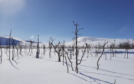
How the snow that controls the spring flood is measured
When winter is at its peak, the Swedish mountain snowpack is measured to assess how much water the spring melt will release – a crucial task that shapres the annual cycle of hydropower.
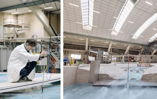
Hydropower at Vattenfall’s R&D centre - where tradition meets innovation
Hydropower has been a reliable, stable and renewable part of the energy system since the late 19th century. However, this does not mean that it is fully developed. The Edit visited Vattenfal...