Section 36 Application Documents
Download the Clashindarroch II Wind Farm Proposal documents by following the links below.
Clashindarroch II - Notice.pdf
Planning Statement
Volume 1 - Non Technical Summary
Volume 1 - Non Technical Summary.pdf
Volume 2 - Environmental Impact Assessment Report
Volume 2 - EIA Report - Table of Contents.pdf
Volume 2 - List of Abbreviations.pdf
Volume 2 - Chapter 1 - Introduction.pdf
Volume 2 - Chapter 2 - Site Description and Design Evolution.pdf
Volume 2 - Chapter 3 - Description of the Development.pdf
Volume 2 - Chapter 4 - Renewable Energy and Planning Policy.pdf
Volume 2 - Chapter 5 - Environmental Impact Assessment.pdf
Volume 2 - Chapter 6 - Scoping and Consultation.pdf
Volume 2 - Chapter 7 - LVIA.pdf
Volume 2 - Chapter 8 - Ornithology.pdf
Volume 2 - Chapter 9 - Ecology.pdf
Volume 2 - Chapter 10 - Cultural Heritage.pdf
Volume 2 - Chapter 11 - Hydrology Hydrogeology and Geology.pdf
Volume 2 - Chapter 12 - Carbon.pdf
Volume 2 - Chapter 13 - Highways, Traffic and Transport.pdf
Volume 2 - Chapter 14 - Noise.pdf
Volume 2 - Chapter 15 - Aviation.pdf
Volume 2 - Chapter 16 - Socio-economics.pdf
Volume 2 - Chapter 17 - Other Issues.pdf
Volume 2 - Chapter 18 - Schedule of Mitigation.pdf
Volume 3a - Figures
Volume 3a - Figures - Table of Contents.pdf
Volume 3a - Chapter 1 - Figure 1.1 - Site Context.pdf
Volume 3a - Chapter 1 - Figure 1.2 - Application Boundary.pdf
Volume 3a - Chapter 1 - Figure 1.3 - Aerial Photograph.pdf
Volume 3a - Chapter 2 - Figure 2.1 - Site Designations.pdf
Volume 3a - Chapter 2 - Figure 2.2 - Initial Site Boundary and Optimised Viewpoints.pdf
Volume 3a - Chapter 2 - Figure 2.3 - Design Development.pdf
Volume 3a - Chapter 2 - Figure 2.4a-y - Optimisation Wirelines.pdf
Volume 3a - Chapter 3 - Figure 3.1 - Indicative Site Layout.pdf
Volume 3a - Chapter 3 - Figure 3.2 - Track Detail.pdf
Volume 3a - Chapter 3 - Figure 3.3 - Indicative Wind Turbine.pdf
Volume 3a - Chapter 3 - Figure 3.4 - Indicative Transformer.pdf
Volume 3a - Chapter 3 - Figure 3.5 - Indicative Turbine Foundation.pdf
Volume 3a - Chapter 3 - Figure 3.6 - Indicative Crane Hardstanding.pdf
Volume 3a - Chapter 3 - Figure 3.7 - Indicative Substation Detail.pdf
Volume 3a - Chapter 3 - Figure 3.8 - Indicative Anemometer Mast.pdf
Volume 3a - Chapter 3 - Figure 3.9 - Indicative Cable Trench Detail.pdf
Volume 3a - Chapter 3 - Figure 3.10 - Indicative Temporary Construction Compound.pdf
Volume 3a - Chapter 3 - Figure 3.11 - Indicative Laydown Area.pdf
Volume 3a - Chapter 7 - Figure 7.1 - Site Location with Topography.pdf
Volume 3a - Chapter 7 - Figure 7.2a - Landscape Character Types.pdf
Volume 3a - Chapter 7 - Figure 7.2b - LCT with BT ZTV.pdf
Volume 3a - Chapter 7 - Figure 7.3a - Landscape Designations.pdf
Volume 3a - Chapter 7 - Figure 7.3b - Landscape Designations with BT ZTV.pdf
Volume 3a - Chapter 7 - Figure 7.4a - Transport with BT ZTV.pdf
Volume 3a - Chapter 7 - Figure 7.4b - Core Paths with BT ZTV.pdf
Volume 3a - Chapter 7 - Figure 7.5a - Blade Tip ZTV A0.pdf
Volume 3a - Chapter 7 - Figure 7.5b - Blade Tip ZTV A3.pdf
Volume 3a - Chapter 7 - Figure 7.6 - Blade Tip and Hub Height ZTV.pdf
Volume 3a - Chapter 7 - Figure 7.7a - Cumulative Windfarm Sites within Study Area.pdf
Volume 3a - Chapter 7 - Figure 7.7b - Cumulative Sites Within Assessement.pdf
Volume 3a - Chapter 7 - Figure 7.7c - Cumulative Sites Within Assessement and Grouping.pdf
Volume 3a - Chapter 7 - Figure 7.8 - Cumulative BT Clash I Clash II ZTV.pdf
Volume 3a - Chapter 7 - Figure 7.9 - Cumulative BT Clash II Cairnborrow Meikleton ZTV.pdf
Volume 3a - Chapter 7 - Figure 7.10 - Cumulative BT Clash II Mid Bailesward ZTV.pdf
Volume 3a - Chapter 7 - Figure 7.11 - Cumulative BT Clash II Dornell ZTV.pdf
Volume 3a - Chapter 7 - Figure 7.12 - Cumulative BT Clash II Group 1 Kildrummy ZTV.pdf
Volume 3a - Chapter 7 - Figure 7.13 - Cumulative BT Clash II Group 2 Edintore ZTV.pdf
Volume 3a - Chapter 7 - Figure 7.14 - Cumulative BT Clash II Group 3 Group 4 ZTV.pdf
Volume 3a - Chapter 7 - Figure 7.15 -Cumulative BT Clash II Group 5 Balquhain ZTV.pdf
Volume 3a - Chapter 7 - Figure 7.16 - Cumulative BT Clash II Group 6 Group 7 ZTV.pdf
Volume 3a - Chapter 7 - Figure 7.17 - Cumulative BT Clash II Aultmore ZTV.pdf
Volume 3a - Chapter 7 - Figure 7.18 - Cumulative BT Clash II Group 8 Rothes III ZTV.pdf
Volume 3a - Chapter 7 - Figure 7.19 - Cumulative BT Clash II Group 9 Group 10 ZTV.pdf
Volume 3a - Chapter 7 - Figure 7.20 - Cumulative BT Clash II Op & Consented In Planning ZTV.pdf
Volume 3a - Chapter 7 - Figure 7.21a - A96 Route Analysis Plan.pdf
Volume 3a - Chapter 7 - Figure 7.21b - Route Analysis A96.pdf
Volume 3b - Visualisations
Volume 3b - Visualisations - Table of Contents.pdf
Volume 3b - Figure 7.22 - Viewpoint 1.pdf
Volume 3b - Figure 7.23 - Viewpoint 2.pdf
Volume 3b - Figure 7.24 - Viewpoint 3.pdf
Volume 3b - Figure 7.25 - Viewpoint 4.pdf
Volume 3b - Figure 7.26 - Viewpoint 5.pdf
Volume 3b - Figure 7.27 - Viewpoint 6.pdf
Volume 3b - Figure 7.28 - Viewpoint 7.pdf
Volume 3b - Figure 7.29 - Viewpoint 8.pdf
Volume 3b - Figure 7.30 - Viewpoint 9.pdf
Volume 3b - Figure 7.31 - Viewpoint 10.pdf
Volume 3c - Visualisations
Volume 3c - Visualisations - Table of Contents.pdf
Volume 3c - Figure 7.32 - Viewpoint 11.pdf
Volume 3c - Figure 7.33 - Viewpoint 12.pdf
Volume 3c - Figure 7.34 - Viewpoint 13.pdf
Volume 3c - Figure 7.35 - Viewpoint 14.pdf
Volume 3c - Figure 7.36 - Viewpoint 15.pdf
Volume 3c - Figure 7.37 - Viewpoint 16.pdf
Volume 3c - Figure 7.38 - Viewpoint 17.pdf
Volume 3c - Figure 7.39 - Viewpoint 18.pdf
Volume 3c - Figure 7.40 - Viewpoint 19.pdf
Volume 3c - Figure 7.41 - Viewpoint 20.pdf
Volume 3d - Figures
Volume 3d - Figures - Table of Contents.pdf
Volume 3d - Chapter 8 - Figure 8.1 Raptor, Owl and Black Grouse Survey Areas.pdf
Volume 3d - Chapter 8 - Figure 8.2 Vantage Point Viewsheds.pdf
Volume 3d - Chapter 8 - Figure 8.3 Flight Activity by Target Species (May 2015 - Sept 2015).pdf
Volume 3d - Chapter 8 - Figure 8.4 Flight Activity by Target Species (Oct 2015 - Mar 2016).pdf
Volume 3d - Chapter 8 - Figure 8.5 Flight Activity by Target Species (Apr 2016 - July 2016).pdf
Volume 3d - Chapter 8 - Figure 8.6A Flight Activity by Target Species (Apr 2017 - August 2017).pdf
Volume 3d - Chapter 8 - Figure 8.6B Flight Activity by Gull Species (Apr 2017 - August 2017).pdf
Volume 3d - Chapter 8 - Figure 8.7 BBS Results 2016 (non-confidential records).pdf
Volume 3d - Chapter 9 - Figure 9.1a Ecological Survey Areas (North).pdf
Volume 3d - Chapter 9 - Figure 9.1b Ecological Survey Areas (South).pdf
Volume 3d - Chapter 9 - Figure 9.2 Designated Sites.pdf
Volume 3d - Chapter 9 - Figure 9.3a Phase 1 Habitats Overview (North).pdf
Volume 3d - Chapter 9 - Figure 9.3b Phase 1 Habitats Overview (South).pdf
Volume 3d - Chapter 9 - Figure 9.4a NVC Communities Overview (North).pdf
Volume 3d - Chapter 9 - Figure 9.4b NVC Communities Overview (South).pdf
Volume 3d - Chapter 9 - Figure 9.5a Potential GWDTEs (North).pdf
Volume 3d - Chapter 9 - Figure 9.5b Potential GWDTEs (South).pdf
Volume 3d - Chapter 9 - Figure 9.6a Forest Age Class and Tree Species (North).pdf
Volume 3d - Chapter 9 - Figure 9.6b Forest Age Class and Tree Species (South).pdf
Volume 3d - Chapter 9 - Figure 9.7a Protected Species Survey Results (North).pdf
Volume 3d - Chapter 9 - Figure 9.7b Protected Species Survey Results (South).pdf
Volume 3d - Chapter 9 - Figure 9.8a Red Squirrel Habitat Quality (North).pdf
Volume 3d - Chapter 9 - Figure 9.8b Red Squirrel Habitat Quality (South).pdf
Volume 3d - Chapter 9 - Figure 9.9a Habitat Features for Wildcat and Pine Marten (North).pdf
Volume 3d - Chapter 9 - Figure 9.9b Habitat Features for Wildcat and Pine Marten (South).pdf
Volume 3d - Chapter 9 - Figure 9.10 Protected Species Monitoring Camera Locations 2018-2019.pdf
Volume 3d - Chapter 9 - Figure 9.11 Automated Bat Detector Locations 2015-19.pdf
Volume 3d - Chapter 9 - Figure 9.12 Bat Activity Survey 2015.pdf
Volume 3d - Chapter 9 - Figure 9.13 Bat Activity Survey 2016.pdf
Volume 3d - Chapter 9 - Figure 9.14 Bat Activity Survey 2019.pdf
Volume 3d - Chapter 10 - Figure 10.1 - CH Assets within Development.pdf
Volume 3d - Chapter 10 - Figure 10.2 - CH Nationally Designated Assets.pdf
Volume 3d - Chapter 10 - Figure 10.3 - 10.9 - Cultural Heritage Wirelines.pdf
Volume 3d - Chapter 11 - Figure 11.1 Regional Hydrology.pdf
Volume 3d - Chapter 11 - Figure 11.2 - Local Hydrology.pdf
Volume 3d - Chapter 11 - Figure 11.3 - Soil Map.pdf
Volume 3d - Chapter 11 - Figure 11.4 - Superficial Geology.pdf
Volume 3d - Chapter 11 - Figure 11.5 - Bedrock Geology.pdf
Volume 3d - Chapter 11 - Figure 11.6 - Groundwater Vulnerability.pdf
Volume 3d - Chapter 11 - Figure 11.7 - Regional Hydrogeology.pdf
Volume 3d - Chapter 11 - Figure 11.8 - GWDTE.pdf
Volume 3d - Chapter 13 - Figure 13.1 - Traffic Study Area.pdf
Volume 3d - Chapter 13 - Figure 13.2 - Traffic Accidents.pdf
Volume 3d - Chapter 16 - Figure 16.1 - Socio-Economic Plan.pdf
Volume 3d - Chapter 17 - Figure 17.1 - Shadow Flicker.pdf
Volume 4a - Technical Appendices (1-6)
Volume 4a - Technical Appendices - Table of Contents.pdf
Volume 4a - Appendix 3.1 - CEMP.pdf
Volume 4a - Appendix 3.2 - Forestry - Part 1.pdf
Volume 4a - Appendix 3.2 - Forestry - Part 2.pdf
Volume 4a - Appendix 6.1 - Scoping Report (2017).pdf
Volume 4a - Appendix 6.2 - Scoping Opinion (2017).pdf
Volume 4a - Appendix 6.3 - Scoping Report 2018.pdf
Volume 4a - Appendix 6.4 - Revised Scoping Opinion (2019).pdf
Volume 4a - Appendix 6.5 - Gatecheck Stage 1 Report.pdf
Volume 4b - Technical Appendices (7-11)
Volume 4b - Technical Appendices - Table of Contents.pdf
Volume 4b - Appendix 7.1 - Visualisation Methodology.pdf
Volume 4b - Appendix 7.2 - Viewpoint Assessment.pdf
Volume 4b - Appendix 7.3 - RVAA.pdf
Volume 4b - Appendix 8.1 - Ornithology Technical Report.pdf
Volume 4b - Appendix 8.2 - Collison Risk Model Calcs.pdf
Volume 4b - Appendix 8.3 - HRA Report.pdf
Volume 4b - Appendix 8.4 - Outline Bird Protection Plan.pdf
Volume 4b - Appendix 9.1 - Phase 1 and NVC Survey Results.pdf
Volume 4b - Appendix 9.2 - Protected Mammal Survey Results.pdf
Volume 4b - Appendix 9.3 - Bat Activity Survey Results.pdf
Volume 4b - Appendix 9.4 - Outline SPP.pdf
Volume 4b - Appendix 9.5 - Outline HMP.pdf
Volume 4b - Appendix 9.6 - Outline FMP.pdf
Volume 4b - Appendix 10.1 - Assessment Methodology.pdf
Volume 4b - Appendix 10.2 - Gazetteer of Heritage Assets.pdf
Volume 4b - Appendix 10.3 - HES Letter.pdf
Volume 4b - Appendix 11.1 - Peat Assessment.pdf
Volume 4b - Appendix 11.2 - Borrow Pit Assessment.pdf
Volume 4b - Appendix 11.3 - Watercourse Crossings.pdf
Volume 4c - Technical Appendices (12-14)
Volume 4c - Technical Appendices - Table of Contents.pdf
Volume 4c - Appendix 12.1 - Carbon Calc Results.pdf
Volume 4c - Appendix 13.1 - Clashindarroch Abnormal Load Route Assessment.pdf
Volume 4c - Appendix 13.2 - Traffic Survey.pdf
Volume 4c - Appendix 13.3 - Accident Data.pdf
Volume 4c - Appendix 13.4 - Outline CTMP.pdf
Volume 4c - Appendix 14.1 - Noise Assessment Checklist.pdf
Volume 4c - Appendix 14.2 - Candidate Wind Turbine Technical Data.pdf
Design and Access Statement
Clash II Design and Access Statement.pdf
Pre-Application Consultation Report
See also

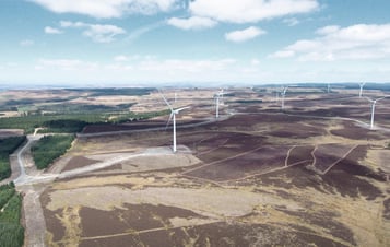
A proposed onshore wind farm development in Aberdeenshire, Scotland.

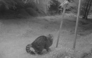
Find out more about the work Vattenfall is doing to protect the Scottish Wildcat habitat d...

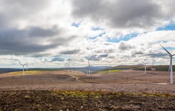
Clashindarroch is an operational onshore wind farm in Aberdeenshire.
